Unforgettable Adventures: Spending Two Days in Yoho National Park
- Sarah

- Sep 22, 2025
- 8 min read

Yoho National Park encompasses 507 square miles within the Rocky Mountains on the western slope of the Continental Divide. It's the smallest of the region's four contiguous national parks (Banff, Jasper, Kootenay and Yoho) along with three provincial parks of British Columbia (Hamber, Mt Assiniboine and Mt Robson Provincial Parks). Yoho was the second national park created in Canada, although this may be contested as Glacier National Park was also created on October 10, 1886.
Prior to becoming a park, this area was home to the Ktunaxa and Secwepemc peoples who were subsequently removed from the land to create the park as their lifestyle and activities were considered incompatible with the management beliefs of parks at that time. My article on Banff National Park has links to additional information on the First Nations of Canada.

Highway 1 and the drive from Golden to Yoho was absolutely stunning and only topped by driving the Icefields Parkway on the way to Jasper. Ashley was driving so I had the chance to take lots of stunning pictures out of the window. While driving in Yoho was the only time that we saw a bear, a black bear walking along the side of the road minding its own business. If you see a bear or any wildlife on the side of the road, you should slow down and pass by it slowly. You should not do what many people were doing, stopping their cars to take pictures and even getting out of them to run down the road after the bear. Harassing bears or other wildlife for photos can be traumatizing to them and can result in injury for you.
I loved our time hiking in YoHo and I hope on the next trip to the Canadian Rockies to spend more time in YoHo and Jasper. On our first day in YoHo we started with a stop at

Wapta Falls, which is easily accessible via a short walk on an easily marked trail through a thick forest. Wapata Falls is the largest waterfall on the Kicking Horse River, at an impressive 59 feet high and 351 feet wide it is a true display of nature's power. The river is a beautiful glacial blue from the same rock flour that colors the glacial lake, Wapta Falls is a great place to take some photos so bring your tripod, but you may also need water protection for your camera. Bringing a rain jacket for yourself is also not a bad idea as the spray from the waterfall can be pretty intense. It was a misty/rainy day when we visited which gave it some moody vibes, that kind of ended up being the theme of the day.
Takakkaw Falls and Yoho Lake Loop
Our next stop was Takakkaw Falls, towers as the second tallest waterfall in Canada at over

1200 feet, Bridalveil (Yosemite) Falls reminds me a lot of Takakkaw Falls. This spectacular waterfall is fed by the Daly glacier in the Waputik Icefield, it's an easy access falls with a short walk down a paved path, while there were some people climbing up next to the falls (not sure you're supposed or that it's a good idea - safety) we opted to just enjoy the view and take some pictures before heading off to our next stop and our hike for the day; the Yoho Lake Loop.
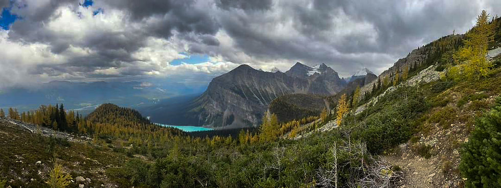
The Yoho Lake Loop doesn't pop up on many blogs as a top or must do hike, I think it's seriously underrated. Maybe it was the misty vibes that made the scenery extra enchanting, but this was definitely a magical hike despite the rain. There's a backpacking loop that you can do which includes the Yoho Lake loop and takes you over to Emerald Lake. The loop is basically a lollipop with an optional side quest to Hidden Lake, the trail reports I read suggested taking the loop counterclockwise as it's easier on the knees going down that way (my knees aren't awesome going downhill).

As we started the hike, we met a man and woman who were yelling for their daughter, we told them we'd keep an eye out as we headed down the path. The stem of the lollipop has a number of switchbacks, at the top of them you can take the short detour to Hidden Lake, this is also where you can decide to go clockwise or counterclockwise. We made the short detour to Hidden Lake, we never ran into the daughter, but the family's car was gone when we got back (it was the only other one there when we parked) after enjoying the views, we continued on our hike. As we hiked through a particularly lovely meadow with trees towering around the edges and a stream running through it, I couldn't help thinking for the second time on this trip that this would be a great place to see a bear. We didn't. But it must have also been on Ashley's mind as a few minutes later she voiced the same thought out loud. I had this same thought again as we crossed the ridgeline and could see open meadows and the hillside below us.
We followed the trail through the trees along the shore of Yoho Lake, it was very overcast

and when we came out from the tree line to the open area around the lake there were several backpackers; some were hanging their packs from the bear poles at the campsite and others were having a snack. Most of the backcountry campsites that I saw were well maintained with bear poles and some even had nice gravel platforms indicating where you should put your tents. We hung out at the lake for a while, when it started sprinkling, we decided to resume our hike.
As we headed back into the tree cover we encountered two trail runners who went flying by us, I give props to anyone who trail runs without falling, but extra props with this kind of

elevation gain. We didn't stay in the tree cover long as after a brief ascent we emerged to cross the ridgeline. Despite the mist, fog and clouds, it was amazing to see Takakkaw Falls from this height as it seemed we were finally even with or above where it started. We could also see glaciers and the small blue dots of lakes at the same altitude as us just across the valley. It was truly spectacular. As we were about a third of the way across the ridge it started to rain, there wasn't any sign of lightening, but we hurried across it anyway as being stuck in the open and pouring rain is never the most fun. The rain kept up for most of our descent and stopped right around the time we arrived at the stick of the lollipop to head back to our car.
Yoho Lake Loop
Distance: 6.7 miles Time: 4 - 5 hours Elevation: 2,043 feet Difficulty: Hard
Emerald Lake and Emerald Basin

Our second day in Yoho was bright and sunny, so we headed to Emerald Lake to see the lake and to hike to Emerald Basin. We slept in a bit which led to a late start (turns out several full days of hiking will make you tired!). To park at Emerald Lake, you do need a Parks Canada Pass and parking is a bit limited, but we were able to snag a spot that required a bit of walking. Emerald lake gets its name from the brilliant green color which is caused by the type of rock producing sediment in the glacial water, this in turn reflects the green spectrum of sunlight instead of the blue spectrum seen in Moraine Lake and many of the other lakes in the area.
Emerald lake is also a great spot go canoeing, it's cheaper than Moraine Lake and Lake Louise. When we were there, you could not use your own boats and there were some other restrictions on water activities due to a disease in fish. You can rent cabins and stay at Emerald Lake and there's also a small cafe/gift shop that is open to the general public.
We started walking around the lakeshore on our way to the trail head, stopping for some pictures. There are multiple trail heads accessible from the lakeshore trail. We had decided to hike Emerald Basin, the trailhead was towards the far end of the lake and pretty quickly starts ascending into a lush subalpine forest, and after a moderate uphill trek (this might be debatable depending on how you're feeling) we emerged from the tree line and were greeted by views of sharp craggy peaks in front of us, snowcapped mountains behind us, and the Emerald River peaking in and out of sight as we made our way to the basin.
Emerald Basin opens up into an amphitheater, carved from glaciers with tall, jagged spires

towering above and evidence of rockfalls littering the ground, you can see some small waterfalls at the back of the basin which feed into Emerald River. We spent some time lounging by the river and enjoying the scenery and a snack until another group arrived and started smoking weed (the smell gives me a terrible headache) so we decided to wander deeper into the basin. There's no clear trail to the back of the basin, although it does seem like there may have been at one point but numerous rockfalls have washed out parts of it. As the sun started to go down, we headed back towards the lake and finished our circuit of it. Overall, this hike wasn't super hard, but the scenery was amazing, and it wasn't a super crowded hike.

Our final stop for the day was Natural Bridge, a rock formation carved out by the milky blue waters of the Kicking Horse River. This spot is a great reminder of what a powerful force water is and how it can shape the landscape. While you often see people walking out onto Natural Bridge, there are signs asking you not to as you never know when something could give way due to erosion or slip off. With its stunning views and breathtaking landscape, Yoho offers less traversed trails for those looking for some solitude and some popular ones if having more company makes you feel more secure in bear country. I give Yoho a 15/10.
Emerald Lake shore and Emerald Basin Hike
Distance: 6.9 miles Time: 3.5 - 4 hours Elevation: 1,302 feet Difficulty: Moderate
Other Notes
Bears - The Canadian Rockies are home to both black and brown (Grizzly) bears and while

most encounters are non-lethal, there are a few things to remember to help keep you safe.
Group hike requirements - check the boards by trailheads to see if it is required to hike in a group
Bear spray is a must; most hotels offer bear spray for rent and sometimes other tourists who are leaving will offer their bear spray for cheap or free since you can't fly with it. You should also make sure you know how to bear spray, you can order practice canisters, it's a good idea to get some and practice deploying it.
Many people suggest bear bells, but there is a lot of debate if they are actually effective and suggest talking or carrying an airhorn or whistle to make extra noise. Many backpacks have whistles built into the chest strap.
Avalanches/Rockslides - Many areas in Yoho National Park are prone to
avalanches/rockslides and Parks Canada doesn't close areas due to risk. Check notice boards at trailheads for any posts about rockslide/avalanche prone areas. Brushing up on what to do in case of a rockslide is also a good idea along with carrying an SOS device like a Garmin InReach or Zoleo.
Clothes - Layers are your friend. During our hikes we wore everything from tank tops to down jackets. I would recommend having a rain jacket and warm layer, whatever that means to you, I run cold so I often have a heavier layer even during warm weather.

Comments