Dog Friendly Adventures: Camping and Hiking in Red River Gorge and Daniel Boone National Forest
- Sarah

- Oct 25, 2025
- 8 min read
Updated: Oct 28, 2025

With all of the funding cuts to our public lands and all the scary things happening with air traffic control (aka Ashley is not getting on a plane right now) we've decided to explore more of the parks, forests and wilderness areas within driving distance. This past Memorial Day, we took advantage of the long weekend to head down to Kentucky to explore Daniel Boone National Forest and the Red River Gorge area.
Daniel Boone National Forest was established in 1937 and is made up of 708,000 acres, it was originally called Cumberland National Forest, but the name was changed in 1966. Once used for industrial logging, you can still find scars from those days dotted across the landscape along with various water features, the area draws over a million visitors annually.
Nestled within Daniel Boone National Forest is Red River Gorge. Considered a bit of a

mecca for climbers on the eastern side of the country, it is most famous for its cliffs, rock formations and arches. This fascinating canyon system is part of the Pottsville Escarpment which is part of the larger Cumberland or Allegany Plateau. If you've ever been to the Seneca Rocks area of West Virgina and feel like the geology is similar, that's because they are both part of the Plateau.
This area is particularly dog friendly with the exception of Natural Bridge State Park; Ashley opted to bring Ronan on this trip (Ryker

was recovering from surgery) making this his first big camping/hiking adventure. There are plenty of dog-friendly private campgrounds around the area, we stayed at Lago Linda, which has a variety of options: tent camping, RV hookups and even cabins. It also has showers (the state campgrounds did not), a cafe (there was live music one night), and lake among other features and is about 30 minutes away from a lot of popular trailheads. I enjoyed our stay at the campground in general, we did have the unfortunate luck of having some really douchy mean girls (and guys) camped across from us.
Auxier Ridge, Courthouse Rock and Double Arch
On Saturday we opted for the very popular Auxier Ridge to Courthouse Rock and Double Arch, this can be done as a loop, but we did it as an out and back. Because this trailhead is so popular, getting to the trailhead early, or alternatively if you plan to backpack or camp along the ridge or just want to catch sunset, late afternoon is a great time to arrive as most people are wrapping up their hikes and heading out.
The ridge itself is a pretty easy hike and has beautiful sweeping views out over the valley, you can even see Double Arch on the opposite side of the valley. This part of the hike took

us longer than necessary due to the number of times we stopped to take pictures and enjoy the view. There are a few campsites along the ridge that I imagine would be lovely to spend the night. Some of the sites had notices posted that some sites that they are being rehabbed, so if you see those signs, please respect them and camp elsewhere.
As we approached Courthouse Rock, we could see a tent pitched on top (presumably from climbers), to make it to the base of Courthouse Rock and to continue on to Double Arch you do have to go down some metal stairs. The stairs are grated so if you have a doggo with you, you may need to carry them or at least give them some confidence (this was probably the only part of the hike that Ronan wasn't leading as he was worried about the stairs).
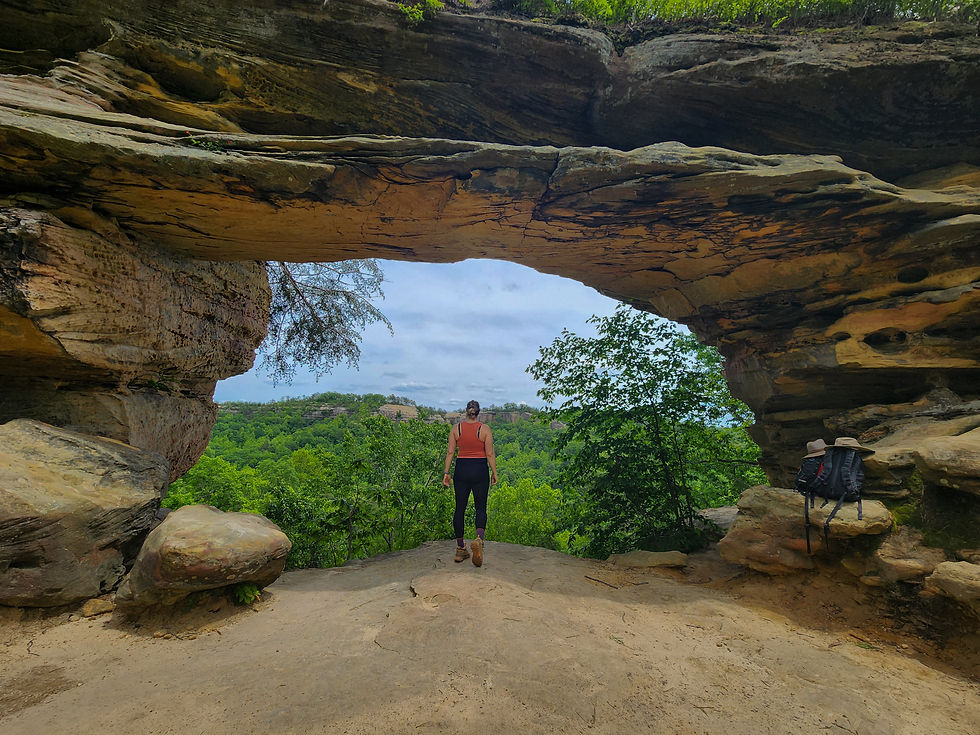
Once you get to the bottom of the stairs you hike along trail #203 (Auxer Branch Trail) and along the valley before you start ascending to Double Arch. When we arrived at Double Arch, there were a few people milling around and taking pictures, so we found a spot to the side of the arch to have lunch. I climbed up on top of Double Arch while Ashley and Ronan hung out down below, unfortunately you can't really tell you're on an arch. You do have to climb up a bit in order to tell that it is indeed a double arch and not a single arch as you cannot see the gap from the ground (the gap is what makes it a double arch).
Heading back down the spur from Double Arch, you can either hike about a mile back to the parking lot to make a loop, or you can back track the way you came. You can also add on Haystack Rock to make this hike longer and there is a second trail that will take you below Auxor Ridge and back to the trailhead. Despite how busy it was, we really enjoyed this hike, there were a lot of doggos on trail and while most owners were respectful, a few were letting their dogs run amok off leash. Friendly reminder to always follow the posted rules about leashes, not all dogs are friendly, not all people like dogs, dogs can disturb wildlife....and walk off cliffs.
Length: 7.4 miles Time: 4-5 hours Elevation: 1,509 feet Difficulty: Moderate
Powder Mill Arch to Blackburn Vista (Abandoned Trail)
On Sunday we were craving something with fewer crowds, and we found Powder Mill Arch

to Blackburn Vista on AllTrails. It had a lot of positive reviews mentioning how great the vista was, but this trail is a bit confusing as I would call it a basically abandoned trail. When I say abandoned, I mean that while people definitely still hike it, and on our way back we ran into a small group that was heading up to the vista to spend the night, but the Forest Service is not actively maintaining it and probably wasn't even before the recent budget cuts ( the Forest Service has never been properly funded).
This lack of maintenance is pretty apparent right away as the sign for the trailhead is on one bank of Indian Creek, but the actual trail is on the other side. There is no visible crossing, and the trail isn't really visible from the far bank, so you just have to pick a spot...your feet will get wet. On a hot day it would probably be super refreshing to spend some time swimming in Indian Creek after your hike, there are some deeper spots where it would be super easy to paddle around.
After crossing the creek and wandering a bit, we found the trail. It is pretty easy to follow,

just overgrown and there were several places with downed trees, some pretty fresh that require a bit of bush whacking and others with a clear path around. A recent rail report mentioned bear scat that was two days old, and we did see fresh bear tracks near where the trail comes out onto the forest service road, so bring your bear canister if you want to backpack this trail. We decided to head to the vista first and while it was beautiful, if you've been spoiled by hiking out west, South America, Canada or any other number of spectacular hiking destinations you may feel a bit underwhelmed. Ashley and I have talked about this feeling as we both experienced it, east coast views are just different.
On our way back to the trailhead, we took the short detour to Powder Mill Arch. There isn't
anything particularly notable or overly impressive about the arch, but it was fun to visit a less popular arch. Apparently, there are other arches that can be reached from the trail, but those posts are all at least a few years old and we didn't see any potential trails. You can also pan for geodes in Indian Creek, when we were crossing back over the creek on our return, there was a woman doing just that. If you don't mind wet feet and a bit of bushwhacking this is a great trail for a bit of solitude.
Length: 6.8 trails Time: 3.5 - 4 hours Elevation: 1,190 feet Difficulty: Moderate
Princess Arch and Chimney Top
Two other popular spots in Red River Gorge are Princess Arch and Chimney Top; both of these are accessible from the same trailhead. The trailhead is located at the end of a gravel road; driving may be slow and dusty as you dodge potholes. The parking lot is a descent size, although I suspect it can get fill up quickly during the busy parts of the day.
Princess Arch is a short easy hike, down a well-maintained path, there is a sign that warns

visitors to be careful and mentions an individual who died falling from Princess Arch. I did a little research on the incident and found that the man fell from the top of the arch while camping, a log rolled out of the fire, and he tried to catch which resulted in falling. Camping is no longer allowed on the arch.
The arch gets its name as people say that it resembles a crown with jewels coming out of the top, in this case the jewels are the trees on top of the arch. Does it look like a crown? Kinda, but you can judge for yourself.
Chimney top is a separate trailhead on the opposite side of the parking lot and is another

fairly easy and short hike that is mostly paved. The trail ends at an overlook with views of the valley, Moon Arch and the "chimneys" - pillars of rock that extend up from the rock wall that extends out into the distance. You can see similar formations at the other Chimney Top in West Virgina, and I personally think the view is better. (You can learn more about that hike here).
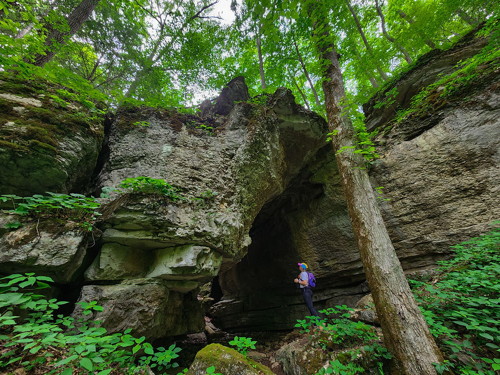
Grey's Arch
On our final day we opted for a short easy hike before heading back home. On the way we stopped at *Daniel Boone Coffee Shop for more coffee and some breakfast burritos, delicious and highly recommend stopping there. Grey's Arch is another fairly short hike, you start dropping in elevation fairly quickly until you reach the bottom of ..., here you can see the rock forms an almost cave like alcove with a waterfall (rainfall dependent), there's a fence and sign clearly stating to stay off the rocks in the area and not to climb up to the arch that way...but of course people were. Including unsupervised children, and some 20 somthing guys trying to get Insta pics.

It's a short but steep uphill to get to the actual arch itself. Grey's Arch boasts an impressive 80-foot span and is 50 feet high, there are a few trails that take you around the base of the arch a bit, but they all dead end. There are signs advising you not to climb on the rocks or arch, but of course there was a dad and his kids doing just that. Even though we arrived around 9-10am, there were already several groups there and it was hard to score a picture without others in it, so if you're after pictures sans others, plan to get there early.
Red River Gorge was a beautiful experience of rock formations and forests. I would love to visit again to climb and backpack. It was also very easy to find hikes, campgrounds and restaurants that allowed dogs, making it a perfect dog-friendly get-away!


Comments